...we should be splashing in salt water and celebrating the end
of an epic journey. Instead, we’re enjoying (as always) the sights and
sounds of Las Vegas and the desert Fall while waiting for more medical tests. (Right. Not
test results… TESTS! The gears of medicine grind slowly. Or, perhaps,
the paddles of medicine get snagged in wild rice bogs…)
Moods are certainly better than ten weeks ago, but symptoms linger and all the important questions remain unanswered.
(Of the two pairs that we shared a campsite with in MN, the Mississippi Challenge 2014 kayakers finished on October 4, and the Crazy Critters are making progress in their canoe)
Friday, October 17, 2014
Thursday, August 7, 2014
DAY 5 (AND OUT) - ANOTHER RAIN-CHECK YEAR (WITHOUT RAIN)
We decided to pull off the river last night.
B1’s health was mildly off when we launched, and his energy was waning, not improving, with all the exertion--even with a slow pace and extra rest (plus fresh air and sunshine). The decision is to return home for medical attention and recuperation. We’re resigning ourselves to yet another Mississippi attempt in 2015.
The decision was super easy... what is more important than enjoying the trek and feeling healthy? I am still stunned, of course. The decision had one particularly hard moment... when a pair of kayakers and a pair of canoeists shared the campsite our second night, portaged the beaver dam and continued to the Gulf.
 |
| Sunrise on our sunset |
Wednesday, August 6, 2014
DAY 4 – BEAVER DAMS AND DAMN EVENTS
Felt Bridge to Coffee Pot Landing - approximately 4.5 miles [BTW: Most
people seem to make it from the Headwaters to Coffee Pot in one day—it’s
taken us three days… B1 noted that if we kept on this pace, we'd finish in 6-1/2 years instead of 2-1/2 months...]
The first half of the day’s journey was characterized by kayaking languidly through an area of butterflies, dragonflies, and flowers, punctuated by humping the boat across beaver dams. Beautiful, but (unfortunately for us today) NOT FUN.
The second half of the day consisted of twisting open-river boating, learning to paddle in actual currents (remember that we have practiced in chop and wind, but always with pedals on open water), so steering together without a rudder and with short turning radii had us bouncing off the banks for a while). B1 is not feeling well, and I ended up often handling the boat by myself--I'm proud of this, but the effort is tremendous for both of us in our own way. The gorgeous weather—and a deer wading in front of us—is not enough to make any of this truly enjoyable. We spill gratefully out of the boat at Coffee Pot Landing. B1 naps all afternoon (after throwing up what little he'd eaten earlier, seemingly from exhaustion). STILL NOT FUN.
I have not seen b1 smile in two days; the exertion is hard on him. His condition is hard on me...
 |
| Traversing a dam |
 |
| A beaver dam at Coffee Pot Landing (we didn't cross it; most portage it) |
 |
| Shot over my shoulder mid-afternoon - Gorgeous day! |
Tuesday, August 5, 2014
COOL COOKING
Brought along a very fun backpacker stove that burns wood. It is of double-wall construction, so the heat of the fire creates convection currents that blast the flames right up at the pan. We can boil water super fast with about one 4-foot stick just slightly thicker than a pencil (snapped shorter than a pencil--Chapstick-sized pieces are optimum). It fits inside our camp pans (a deeper pan with a lid that's also a frying pan), along with the matches and a tiny bottle of dish soap. I love how cleanly it burns (the ashes are like confetti) and how quickly it cools off for repacking.
 |
| Solo Stove |
DAY 3 – WALKING THE BOAT
Wanagan Landing to Felt Bridge - approx 5.5 RM
Today was quite the day for walking.
Today was quite the day for walking.
After a short wind through somewhat clearer grasslands (OMG, the FLOWERS), our first
portage took us around Vekin’s Dam (an early-twentieth-century wood dam,
built for logging purposes). The portage was a trail through the woods,
where we carried all the equipment, including the boat; then had lunch
before repacking and shoving off again. It took somewhat longer than an
hour and was energy-intensive, but not entirely unpleasant.
After the dam, we encountered a long stretch of “rapids” with low water. The boat kept grounding on sandbars, so we had to lift ourselves out of the boat and drag it, bumping into rocks and submerged logs. For a brief time this seemed fun; African Queen slogging through ankle-deep then thigh-deep clear bubbling water--after all, people spend a lot of time and money to hike the length of the river narrows in Zion! But energy was already at a premium, and it took a lot of focus to maneuver. B1 was getting particularly bunged up and clumsy with exhaustion (although both of us were bruised). Occasionally optimism set it and we’d climb back into the boat, only to grind to a halt a couple of turns down the river. Grrr. The afternoon was getting along when we spoke to a man on the bank, and he recommended a camping spot quite a few miles before our planned take-out. Relief again to have a place to pitch our tent on this strange river trek.
We found the Felt Bridge (a reproduction nineteenth-century wooden design, no longer connected to a regular roadway) where we tied up to a signpost, let the boat float against the abutment, and passed the gear directly overhead from boat to bridge. We set up early enough that b1could get some much-needed rest and we could cook a “real” dinner on our awesome stove. We feasted on mashed potatoes with bacon, cheese and chipotle, with a dessert of oatmeal. It’s amazing what boiling water can accomplish. (It’s also amazing how little we were actually eating, considering the extent of our physical accomplishments.)
Quiet splashing at the river in the night after bedtime--maybe otters.?
 |
| Post-portage launch site |
 |
| Walkin' the boat |
 |
| Meadow flowers on the riverbank |
 |
| Felt Bridge campsite |
 |
| Peeking out from under its overnight roof |
Monday, August 4, 2014
DAY 2 - WANAGAN LANDING
Woke up and consulted about the schedule. It took no time at all to determine that we needed/wanted a day to rest (from our weekends, not from our two miles) and repack. So b1 rested and I repacked! And then I rested, too!
So much was accomplished, and we got to meet a number of really nice people who kayaked through (a pair from Missouri, out for the day only) or locals who stopped in by car or ATV to view the river.
We had beautiful weather again, too.
So much was accomplished, and we got to meet a number of really nice people who kayaked through (a pair from Missouri, out for the day only) or locals who stopped in by car or ATV to view the river.
We had beautiful weather again, too.
 |
| Minnesota River Trail campsite shelter and our tent |
 |
| Frog in the grass by the boat |
day 2 - wanagan landing, MN -- MT 2

dropped in just before sunset. I was thinking that I might have to african queen it for 2 miles and walk the boat downriver (which is actually N here, which is weird in its own right) ... but the river was deeper than that so tons of rowing with my accomplice occasionally poling with a kayak paddle from the back.
the river is thin, shallow, and occasionally boggy here ... a couple different times we had to back out and re-direct to a more major channel, all the time in ever-more-thinning light.
we finish I'm the dark at 22:30, and don't get to bed until 00:30.
a let start had us packing the boat haphazard. a late arrival had us disgorging equipment willy nilly. there's no such thing as a "free slug" in endurance travel and clumsy packing technique qualifies. almost certainly we'll pay the price for that tomorrow.
Sunday, August 3, 2014
DAY 1 – LAUNCH AND SUNSET TOUR
Three days earlier, we’d hidden the boat behind some bushes at Gulsvig
Landing, and (of course) it was still there, waiting to pack and launch
through the wild rice. As everything else had that long day, it took
slightly longer than we’d hoped to prepare and push off, but we set off
with equal parts enthusiasm and exhaustion.
The river twisted through the reeds and grasses, and it was pretty challenging to follow the main current. The sun set beautifully, and the northern twilight lingered with us for a while before the mists started rising. It was challenging enough to paddle that I didn't take any photos, but I did check Google maps once or twice when spirits started to lag, and could see that we were making progress. We’d visited our unmarked destination the previous week, so knew vaguely where it was on map.
I’m a little ashamed to say that I gasped in relief when we finally sighted the canoe-landing sign at Wanagan Landing. The headlamp beam had been fighting the mists, and I had let myself become worried that we would slip past the campsite and spend the night looking for a dry place to sleep.
I unpacked the boat in the dark while b1 set up the tent. Frogs (I think!) rustled around me, and the mosquitoes were a moderate nuisance. I had let myself get too cold and stupid, and was glad to strip off the clammy spandex and climb into the sleeping bag. The proportion of enthusiasm to exhaustion was no longer in balance.
[One map says 2 miles. Another says 3 miles. I’d based the first leg of the trip on the first map and our ability to go 2 miles before night fell. Hmmmm!]
 |
| At Gulvig Landing |
 |
| The boat was in the bog for three nights |
 |
| We got covered in wild rice |
DAY 1 – HEADWATERS
As they say in Italy, the headwaters were in restauro (essentially, a bridge and path were under construction, and they’d blocked the river). During reconnaissance,
we determined that our boat would struggle with the shallow river, so we waded (without
the boat) at the headwaters and put in 2 miles below, at Gulsvig Landing.
[BTW: All the river runners we met later had put into Lake Itasca above the headwaters, portaged the stepping stones, and floated under the construction fence...]
[BTW: All the river runners we met later had put into Lake Itasca above the headwaters, portaged the stepping stones, and floated under the construction fence...]
 |
| Headwaters Signpost |
 |
| Stepping Stones Across the Mississippi |
 |
| The top of the river is under construction |

day 1 - 0 miles traveled
if all goes well (and it's been going very slowly so far) we'll put in today.
[I've been -and still am- sick for weeks ... HIGHLY unusual for me - 1st time in the 21st century ... and it's kept me from working on the website and giving you a verbal lay of this 'blog land ... my hope is to shoot a picture every morning with the miles traveled [MT] to that point ... my signal is spotty so there'll be occasional delays ... enjoy your read.]
Saturday, August 2, 2014
ALL PACKED UP
Most clothes and supplies get stowed inside the boat; just a few larger items will be tied atop the stern. Because access to the interior is through three small, round hatches, we've stuffed the gear into a colorful collection of long, sausage-shaped bags. Some less-water-resistant items (e.g., paper maps) are packed in sealable, "dry bags."
There are weight constraints because we'll have to portage around some obstacles at the beginning of the trek. We aren't as careful as the through-hiking community (who weigh every safety pin because they carry every safety pin), but packing entailed a lot of hard decisions nevertheless.
There are weight constraints because we'll have to portage around some obstacles at the beginning of the trek. We aren't as careful as the through-hiking community (who weigh every safety pin because they carry every safety pin), but packing entailed a lot of hard decisions nevertheless.
 |
| Stuff bags stack like cord wood |
 |
| Color-coded according to content |
Thursday, July 31, 2014
A SCHEDULE TO BEAT...
...we'll travel faster than the raindrop, but stop to eat and sleep...!
 |
| Wall Display at the Lake Itasca Visitor Center |
Wednesday, July 30, 2014
RECONNOITERING
This is what two days of reconnoitering looks like:
Scope maps, drive on back roads, stop at bridges and culverts, admire the Mighty Miss where it is still extremely modest, hike into canoe landings, nap, discuss, repeat.
The goal is to confirm a safe and reasonable place and time to launch. Gotta take into account: park construction at the top of the headwaters, the height of the wild rice (creates challenging navigation), river levels at rocky sections, plus our transportation and daylight schedule.
Tuesday, July 29, 2014
LAS VEGAS TO THE HEADWATERS
Blue kayak. Blue car. Red trailer!
 |
| Leaving LV at sunset |
 |
| Devil's Tower, WY |
 |
| Rest Area in North Dakota |
 |
| Lake Itasca State Park Pine Ridge Campground |
Sunday, July 27, 2014
2013
Last year, the kayak traveled 5,000 miles upside-down without touching
water (other than rainwater). It was a disappointing and sad journey.
The river bags were packed, the kayak rode comfortably atop my
daughter’s CR-V, and we were in Iowa, three days and one state away from
the headwaters, participating in RAGBRAI (Or eating pie... Or both...) when
we got news that my dad had suffered a serious heart attack. I left for
the hospital in Montana, where he’d been fishing, and he passed away
July 28 with his family around him.
B1-66er, my daughter, her car and the boat made a U-turn at the Mississippi River (Literally. In Fort Madison, IA), and finished their all-too dry path through Wyoming to Montana, and then south again to Las Vegas. It’s hard to balance the sadness of a parent’s death with the disappointment of a lifetime goal postponed. Happily, the trip was postponed only one year, and once again, the river bags are packed and the kayak is traveling to Minnesota, this time on a tiny red trailer behind B1’s PT Cruiser. Looking forward to a watery trip in 2014.
B1-66er, my daughter, her car and the boat made a U-turn at the Mississippi River (Literally. In Fort Madison, IA), and finished their all-too dry path through Wyoming to Montana, and then south again to Las Vegas. It’s hard to balance the sadness of a parent’s death with the disappointment of a lifetime goal postponed. Happily, the trip was postponed only one year, and once again, the river bags are packed and the kayak is traveling to Minnesota, this time on a tiny red trailer behind B1’s PT Cruiser. Looking forward to a watery trip in 2014.
 |
| Leaving LV via I-15, Virgin Canyon, AZ |
 | |
| In Ledges State Park, near Boone, IA |
 |
| View of 2013 RAGBRAI, Des Moines, IA |
 |
| Deal Christensen, Jr. (Obituary Photo) |
RIVER READING
I have two Mark Twain books loaded in my phone to read in the tent on evenings after we’ve started the river trip: Huckleberry Finn and Life on the Mississippi. I haven’t specifically looked for other Mississippi literature, but expect to encounter new titles as we follow the river. (Suggestions welcome!)
Last month, I bought and enjoyed The Control of Nature by John McPhee. The book consists of three essays about how humans battle nature on a huge scale, including how the Army Corps of Engineers controls the outflow of the Mississippi River at the confluence of the Mississippi at the Red River and the divergence of the Atchafalaya River. (The other two essays address lava flows in Iceland and mud/rock flows in Los Angeles). I gained a renewed appreciation for the tenacity/stubbornness of people and their ability to impact their environment.
Not long after I read the book, I happened on a news article about rising sea water levels in Miami—where humans have not yet begun to fight nature on such a massive scale. The article implies that humans are in denial about the future of global warming, and that, if there were only public will, the city could hold back the tides.
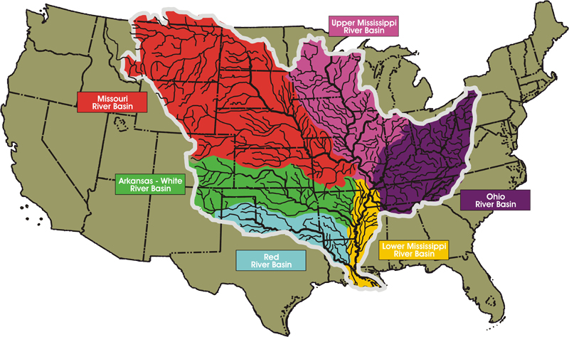
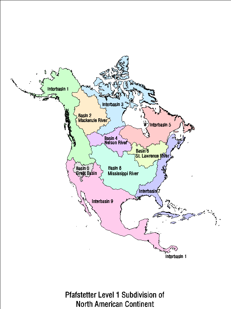
RIVER BASIN MAPS(!)
In most of Utah and Nevada, rivers don’t run to the sea, and, instead, evaporate within the Great Basin. In the Rocky Mountains, the Continental Divide earns a lot of attention, with signs posted each time a road crosses it. Meanwhile, by the time it reaches the delta, the Mississippi River collects and drains the massive center of North America, including: the Upper Mississippi River Basin, the Missouri River Basin (including the Platte out of Denver), the Ohio River Basin (barely separated geographically from the adjacent St. Lawrence River Basin--Great Lakes--drainage), the Arkansas-White River Basin (including southern Colorado and across Oklahoma), and the Red River Basin (which makes me think of the folk song and some good friends in Texas). Three other rivers drain north and east from the center of the continent, while the rest of the rivers just flow to the nearest ocean.
MAPS!!!
Basin Map
Continent Basin Map
Divide Map
MAPS!!!
Basin Map
Continent Basin Map
Divide Map
WHERE DO WE GO?
The Mississippi River is about 2,400 miles long from the headwaters to the Gulf of Mexico and runs through and/or borders ten states. It starts wholly within Minnesota (about 1/4 of the length of the river is in Minnesota, approximately 640 miles). It ends wholly within the state of Louisiana, many miles (almost 100) past New Orleans, at the tip of a long channel that extends into the delta at Louisiana’s toe. Between MN and LA, it flows past: Wisconsin, Iowa, Illinois, Missouri, Kentucky, Tennessee, Arkansas, and Mississippi.
There’s a terrific map on the Wikipedia page.
There’s a terrific map on the Wikipedia page.
Subscribe to:
Posts (Atom)